Features
Bend and Rapid City byways compared for volcanic and granite rock
Cascade Lakes Scenic Byway near Bend runs on volcanic rock, while Rapid City's Black Hills routes and Needles Highway cut granite. Here is how each is signed.
What to take away
- The Cascade Lakes Scenic Byway west of Bend, Oregon, crosses volcanic terrain managed largely by the Deschutes National Forest, with signs tied to Forest Service byway standards.
- Black Hills routes out of Rapid City, South Dakota, reach Mount Rushmore and Crazy Horse on granite, signed by state and federal agencies rather than a single byway program.
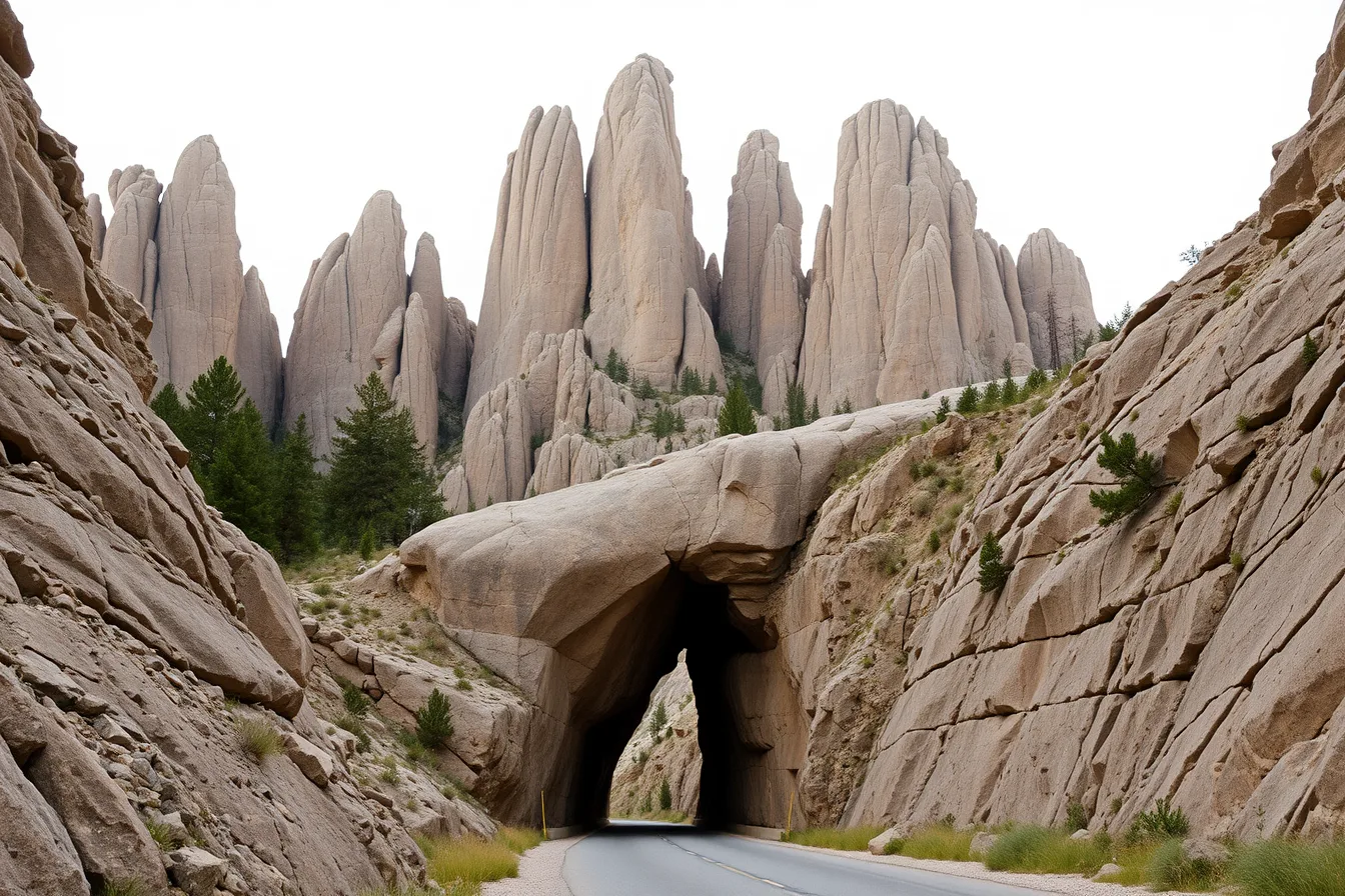
- Needles Highway, the South Dakota Highway 87 segment through Custer State Park, is known for granite spires and narrow tunnels, not for volcanic rock.
- Mount Rushmore National Memorial and Devils Tower National Monument sit in National Park Service hands; the surrounding Black Hills National Forest and most Cascade Lakes land sit with the Forest Service.
- Geology drives the drivevolcanic cones, lava flows and pumice near Bend, versus granite core stone, pegmatite and caves in the Black Hills.
- Sign clutter, closures and seasonal gates differ enough that the two trips reward different planning.
Volcanic rock in Oregon, granite in South Dakota
The two corridors sit on different geologic foundations, and that difference shows up at every pullout.
West of Bend, the Cascades are a volcanic arc. Lava flows, cinder cones and pumice fields built the ground the road crosses. The high desert east of the mountains gives way to lodgepole pine and bare obsidian outcrops as you climb toward the lakes.
The Black Hills are a granite core surrounded by layered sedimentary rock. Erosion stripped the softer layers and left granite spires, fins and narrow canyons. That is why Needles Highway looks nothing like a Cascade pass.
The National Park Service keeps a plain-language geology reference for the formations that parks and byways cross, useful when a roadside sign names a rock type you do not recognize. The Geology (U.S. National Park Service) pages explain volcanic and granite rock in terms a driver can carry to the next overlook.
Volcanic ground is not always quiet ground. Parts of the Cascades remain seismically active, and the U.S. Geological Survey tracks that activity. The Earthquake Hazards Program | U.S. Geological Survey is the reference for hazard context along western byways, including the Oregon Cascades.
Granite country has its own hazards, mostly rockfall and ice in the tunnels and on the switchbacks. Neither corridor is dangerous on a normal summer day. Both reward attention after storms.
Cascade Lakes Scenic Byway and its Forest Service signing
The Cascade Lakes Scenic Byway runs southwest from Bend past Mount Bachelor and a chain of lakes. It is the signature drive on the Oregon side of this comparison.
Signing starts in Bend. Route markers follow the national byway marker system, a brown and white shield with a stylized arrow. If the symbol is unfamiliar, read a scenic byway route marker before you go, because the same shield appears on Forest Service and state routes across the country.
The byway is a Forest Service road, Oregon Highway 46 in part, and the Deschutes National Forest manages the corridor and its recreation sites. Expect Forest Service signage at trailheads, boat ramps and campgrounds rather than park-style entrance stations.
Federal byway status is not decorative. The Federal Highway Administration runs the National Scenic Byways Program and lists designated routes, including this one. The Home Page | America's Byways is the official listing and the place to confirm designation and resources.
Place names along the route come from the federal geographic names system. The U.S. Board on Geographic Names | U.S. Geological Survey covers the Northwest-Pacific Islands region, which includes Oregon names you will see on signs and maps.
Some land near the corridor is not Forest Service at all. BLM manages large tracts in central Oregon, and its recreation rules differ from Forest Service rules on dispersed camping and fire restrictions. The Recreation and Visitor Services | Bureau of Land Management page lays out those rules and byway information.
What the drive looks like
From Bend, the road climbs through ponderosa pine into higher country. Mount Bachelor rises on the left. Then the lakes arrive in sequence: Elk Lake, Hosmer, Lava Lake, Cultus, and the twins.
Distances are short. The full byway is roughly a half-day drive without stops, longer with them. Volcanic landmarks sit close to the pavement, including lava fields and cinder cones you can walk on.
Black Hills routes to Mount Rushmore and Crazy Horse
Rapid City is the gateway. From downtown, US 16 and US 16A head southwest into the Black Hills toward Keystone and Mount Rushmore.
Mount Rushmore National Memorial is a National Park Service unit. The sculpture sits on granite in the Harney Range, and the memorial has its own entrance, parking structure and seasonal hours.
Crazy Horse Memorial is a separate, privately operated site on US 16/385 between Custer and Hill City. It is not a Park Service unit and not a federal reservation. Tickets are separate from Mount Rushmore.
The two sites pair naturally on one loop. Most drivers run Mount Rushmore first, then continue south toward Custer and Crazy Horse, then work back through Hill City or Keystone.
The corridor is not one designated byway with one manager. It is a set of state and federal highways through the Black Hills National Forest, Custer State Park and several small communities. That means mixed signing.
Planning helps here more than it does near Bend, because the loop has more decision points and more traffic. If you want a structured approach, plan scenic routes with a corridor choice and a fallback before you commit to a specific day.
Worked example: a one-day Black Hills loop
Start in Rapid City on US 16 west. Stop at Mount Rushmore National Memorial in the morning, before tour buses fill the parking decks.
Continue south on US 16A through Keystone, then take the Iron Mountain Road alignment toward Custer State Park. This is where the granite tunnels and pigtail bridges begin.
One-day Black Hills loop
- Rapid City to Mount Rushmore on US 16, roughly 30 minutes.
- Mount Rushmore to Crazy Horse on US 16/385, roughly 40 minutes with traffic.
- Crazy Horse to Custer on US 16, roughly 20 minutes.
- Custer to Needles Highway on SD 87, then north through the tunnels.
- Needles Highway north to Hill City, then back to Rapid City on US 385 and I-90.
That is a full day with stops. Add a second day if you want Sylvan Lake, Wind Cave or the Mickelson Trail.
Needles Highway and its granite markers
Needles Highway is the common name for the SD 87 segment through Custer State Park between Sylvan Lake and the Cathedral Spires area. It is the granite centerpiece of the Black Hills.
The needles themselves are granite fins and spires, weathered along joints into narrow towers. The road threads between them and through hand-cut tunnels, including the famous Needle's Eye.
Signing is state and park, not national byway. South Dakota DOT posts the route markers and warning signs. Custer State Park manages the road corridor inside the park and charges an entrance fee.
Vehicle size matters. The tunnels are narrow and low, and RVs and trailers are commonly advised to avoid the segment. Check current restrictions before you commit a large vehicle to it.
The granite markers here are literal: rock walls, tunnel portals cut through stone, and pullouts where the geology is the attraction. It is the opposite experience from a wide volcanic byway with long sightlines.
Which Forest Service and Park Service units manage each
Management determines signing, fees, closures and camping rules. The two regions differ sharply.
Which units manage each
Cascade Lakes Scenic Byway (Bend, OR)
- Primary federal manager
- Deschutes National Forest, US Forest Service
- National Park Service role
- None on the byway itself; Newberry National Volcanic Monument is nearby
- State role
- Oregon DOT signing and highway maintenance
- Rock type
- Volcanic: lava flows, cinder cones, pumice
- Signature feature
- Chain of lakes below Mount Bachelor
- Fees
- No byway fee; some sites charge day-use
- Season
- Snow closes high sections into late spring
Black Hills routes and Needles Highway (Rapid City, SD)
- Primary federal manager
- Black Hills National Forest, US Forest Service; Custer State Park, state
- National Park Service role
- Mount Rushmore National Memorial; Wind Cave National Park; Jewel Cave National Monument
- State role
- South Dakota DOT signing; Custer State Park entrance fee
- Rock type
- Granite core with sedimentary layers, pegmatite, caves
- Signature feature
- Granite spires and narrow tunnels
- Fees
- Park fee for Custer State Park; Mount Rushmore parking fee
- Season
- Open year round, ice and closures in winter
Newberry National Volcanic Monument, south of Bend, is a Forest Service unit and a useful add-on to the Cascade Lakes drive. It is not a Park Service site.
On the South Dakota side, the Park Service units are the anchors: Mount Rushmore, Wind Cave and Jewel Cave. The Forest Service manages the surrounding forest and much of the dispersed recreation.
Comparing geology against sign and route conditions
Rock type shapes what you see. Management shapes what you can do.
Volcanic terrain near Bend gives long views, rounded slopes and dark lava ground. Granite terrain gives vertical walls, tight corners and shade. Drivers who like open sightlines prefer the Cascades. Drivers who like technical roads prefer the Black Hills.
Signing differs too. The Cascade Lakes route uses consistent byway markers tied to a national program. The Black Hills loop mixes state highway markers, park signs and private attraction signs, which is harder to follow at speed.
Season is the other split. Cascade Lakes is a warm-season drive, with snow closing the high country into late spring and sometimes early summer. The Black Hills loop runs year round, but winter ice and wind make the tunnels and switchbacks a different proposition.
If you are weighing timing, work out which season suits a scenic routes trip before booking.
Local knowledge fills gaps that signs cannot. Ranger stations, chamber offices and volunteer groups publish current conditions and closures. That kind of local scenic routes knowledge is worth gathering for either corridor, especially after storms.
Both trips reward detours. Oregon has lava caves, hot springs and high-desert towns. South Dakota has historic mining towns, caves and roadside sculpture. If you like ghost towns, overlooks and similar stops, either corridor can absorb an extra day.
- Confirm current road status with the managing forest or park office.
- Check tunnel and vehicle size restrictions on Needles Highway.
- Carry a paper map, because cell coverage is patchy on both corridors.
- Note fee sitesCuster State Park, Mount Rushmore parking, Newberry Monument.
- Check fire restrictions in central Oregon and South Dakota before any dispersed camping.
- Plan fuel stops, since services are sparse on the Cascade Lakes route.